Property Record
E Dunbar Rd, Monroe, MI 48161

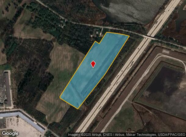
This Property Is For Sale
NEARBY LISTINGS FOR SALE OR LEASE
-
-
-
No Photo
-
View all Monroe listings for sale on LoopNet.com
Property Detail
E Dunbar Rd
12-020-266-00
MAP 27 DESCRIBED IN RECORDED DOCUMENT 2020R21473 AS: PART OF PC 561 DESC AS COM AT THE CL OF DUNBAR RD & THE W'LY LI OF PC
Commercialacreage
Monroe
X
Michigan
26115C0244F
16.77 AC
2024
Monroe County
2025
Detroit
832200
Monroe, MI
DEMOGRAPHICS near E Dunbar Rd
1 Mile
3 Mile
5 Mile
2024 Total Population
1,357
30,366
49,101
2029 Population
1,384
30,866
49,887
Pop Growth 2024-2029
+ 1.99%
+ 1.65%
+ 1.60%
Average Age
38
41
42
2024 Total Households
445
12,389
20,148
HH Growth 2024-2029
+ 2.02%
+ 1.54%
+ 1.52%
Median Household Inc
$42,083
$54,895
$60,109
Avg Household Size
2.50
2.30
2.30
2024 Avg HH Vehicles
2.00
2.00
2.00
Median Home Value
$81,097
$144,236
$164,801
Median Year Built
1950
1959
1966
Nearby Places
Map Layers
Map Styles
 Street
 Aerial
- Restaurants
- Banks
- Shops
- Fitness
- Groceries
PUBLIC TRANSPORTATION
AIRPORT
Detroit Metro Wayne County
DRIVE
WALK
Distance
Detroit Metro Wayne County
33 min
27.6 mi
Freight Ports
Port of Toledo
DRIVE
WALK
Distance
Port of Toledo
31 min
22.1 mi
Nearby Properties
Address
Land Use
TOTAL SIZE
Lot Size
Zoning
Address
Land Use
TOTAL SIZE
Lot Size
Zoning
97.18 AC
Address
Land Use
TOTAL SIZE
Lot Size
Zoning
5,088 SF
123.61 AC
R-1A
Address
Land Use
TOTAL SIZE
Lot Size
Zoning
48,845 SF
163.20 AC
R-1A
Address
Land Use
TOTAL SIZE
Lot Size
Zoning
Address
Land Use
TOTAL SIZE
Lot Size
Zoning
109,073 SF
47.32 AC
Address
Land Use
TOTAL SIZE
Lot Size
Zoning
Address
Land Use
TOTAL SIZE
Lot Size
Zoning
183,508 SF
70 AC
Address
Land Use
TOTAL SIZE
Lot Size
Zoning
3.97 AC
Address
Land Use
TOTAL SIZE
Lot Size
Zoning
13.60 AC
Address
Land Use
TOTAL SIZE
Lot Size
Zoning
108,575 SF
38.21 AC
R-1A
Address
Land Use
TOTAL SIZE
Lot Size
Zoning
43,528 SF
16.06 AC
MHP
Address
Land Use
TOTAL SIZE
Lot Size
Zoning
507.34 AC
R-1A
Address
Land Use
TOTAL SIZE
Lot Size
Zoning
317,482 SF
20.53 AC
Address
Land Use
TOTAL SIZE
Lot Size
Zoning
2,195 SF
86.71 AC
MHP
Address
Land Use
TOTAL SIZE
Lot Size
Zoning
PS PUBLIC
Address
Land Use
TOTAL SIZE
Lot Size
Zoning
Address
Land Use
TOTAL SIZE
Lot Size
Zoning
41 AC
MHP
Address
Land Use
TOTAL SIZE
Lot Size
Zoning
412,877 SF
22.35 AC
R-1A
Address
Land Use
TOTAL SIZE
Lot Size
Zoning
200,700 SF
9.95 AC
R-1A
Address
Land Use
TOTAL SIZE
Lot Size
Zoning
13.38 AC
Address
Land Use
TOTAL SIZE
Lot Size
Zoning
75,437 SF
8.74 AC
R-1A
Address
Land Use
TOTAL SIZE
Lot Size
Zoning
6.78 AC
Address
Land Use
TOTAL SIZE
Lot Size
Zoning
975 SF
34.50 AC
MHP
Address
Land Use
TOTAL SIZE
Lot Size
Zoning
Address
Land Use
TOTAL SIZE
Lot Size
Zoning
150,200 SF
5.68 AC
R-1A
Address
Land Use
TOTAL SIZE
Lot Size
Zoning
106,200 SF
10.83 AC
R-1A
Address
Land Use
TOTAL SIZE
Lot Size
Zoning
37,210 SF
0.57 AC
R-1A
Address
Land Use
TOTAL SIZE
Lot Size
Zoning
151,101 SF
5.16 AC
R-1A
Address
Land Use
TOTAL SIZE
Lot Size
Zoning
66,154 SF
6.22 AC
Address
Land Use
TOTAL SIZE
Lot Size
Zoning
16.65 AC
The World's #1 Commercial Real Estate Marketplace
Connect with us
© 2025 CoStar Group
The information above has been obtained from sources believed reliable. While we do not doubt its accuracy we have not verified it and make no guarantee, warranty or representation about it. It is your responsibility to independently confirm its accuracy and completeness. Any projections, opinions, assumptions, or estimates used are for example only and do not represent the current or future performance of the property. The value of this transaction to you depends on tax and other factors which should be evaluated by your tax, financial, and legal advisors. You and your advisors should conduct a careful, independent investigation of the property to determine to your satisfaction the suitability of the property for your needs.